
 Sentiero n. 4: da Valdicastello Carducci a Le Mulina
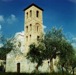
Dalla parte alta del paese di Valdicastello Carducci si imbocca sulla destra Via Goito, che diventa ben presto mulattiera ed inizia a risalire la valle, toccando le antiche miniere di ferro. Lasciata sulla destra, in loc. Mulini di S. Anna, una traccia che sale fino alla Culla, si prosegue nel bosco, sbucando poco dopo sulla rotabile nei pressi di S. Anna di Stazzema. Si lascia l’asfalto dopo pochi metri per riportarsi sulla mulattiera, che in breve arriva proprio sotto la chiesa, da cui nella piazza. Il sentiero 4 si tiene verso destra, attraversando il piazzale-parcheggio di S. Anna. La mulattiera riprende tra boschi e casette, sfociando poi sulla strada fino alla borgata di Sennari. Qui si torna nel bosco, verso sinistra, e si risale decisamente verso la Foce di Farnocchia, punto più alto (873 m) del nostro viaggio. La discesa avviene su una larga e ben conservata mulattiera a risvolte, che poco prima di Farnocchia va ad inserirsi sul sentiero n. 3, proveniente da Capezzano monte. Il 3-4 entra in paese, passando accanto alla chiesetta del Carmine e separandosi poi nei pressi di una scalinata. Il n. 4 scende, percorrendo poi via Broto ed esce da Farnocchia attraversando la strada, per girare a sinistra e immettersi sulla traccia che, sempre nel bosco e talvolta su bel selciato, arriva in circa 40 minuti alla chiesa delle Mulina. Da qui ci si tiene a sinistra, per percorrere gli ultimi metri giungendo sulla strada asfaltata che dalle Mulina porta verso Ponte Stazzemese.
Path no. 4: From Valdicastello to Le Mulina
At the top of the village of Valdicastello Carducci enter the uphill via Goito on the front right; this quickly becomes a mule track climbing the valley and passing historic iron ore mines. At loc. Mulini di S. Anna , a track leads off on the right to La Culla. Don’t take this but stay going forward and soon you reach the main road to S. Anna. After a few metres on the road you come to a hairpin bend from where the path restarts front left into the wood. The path emerges under the church and square of S. Anna. Turn right across the square and opposite the carpark, the path goes up to the right, skirting the wood, and soon working its way through some houses to rejoin the road at Sennari. Turning right after a few metres the path leaves the road on your left and steeply tracks up to Foce di Farnocchia with the path’s high point m 873.
The descent follows a well- preserved mule track with some hairpins; it merges with path 3 which has come from Capezzano Monte just before reaching and crossing Farnocchia. The two paths flank the Carmine church before track 4 descends some steps, and following via Broto, it leaves Farnocchia . Cross the road and the path goes left into the wood; the path, sometimes very well preserved, reaches the church at Le Mulina after about 40 minutes. At the church a final few metres on the left take you onto the main road going down from Le Mulina to Ponte Stazzemese.
|
Località |
Quota |
Andata |
Ritorno |
|
Valdicastello – Sant’Anna |
102 |
1 ora 30 min. |
1 ora 20 min. |
|
Sant’Anna – Foce di Farnocchia |
650 |
1 ora |
50 min. |
|
Foce di Farnocchia – Farnocchia |
873 |
40 min. |
50 min. |
|
Farnocchia – Culerchia (Le Mulina) |
652 |
50 min. |
1 ora |
|
Culerchia (Le Mulina) |
547 |